Research client side draggable route selection with pgRouting
Created by Ko Nagase, Georepublic Japan
Agenda
- Self-introduction
- Background
- Draggable routing frameworks
- Leaflet Routing Machine (LRM) pgRouting plugin
- Future plans


Ko Nagase (sanak)
- Developer, Georepublic Japan
- pgRouting contributor
- Initial Windows binary (MinGW) creator
- Fixed/Improved Alpha Shape function
- Multi OS (Mac/Win/Linux) build tester
- QGIS pgRoutingLayer plugin contributor
- Supported pgRouting v2.0 functions
- Supporting pgRouting v2.1 functions is coming soon!
QGIS pgRoutingLayer plugin demo
Background
- Specific pgRouting use case
- All possible routes
- Round trip case
- Parallel edges case
- K shortest path (KSP) limitations
- Necessity of draggable routing
All possible routes
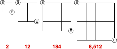
- Known as "Self-avoiding walk"
https://en.wikipedia.org/wiki/Self-avoiding_walk - Combinatorial explosion
https://www.youtube.com/watch?v=Q4gTV4r0zRs
Round trip case
- The combinatorial explosion becomes worse...
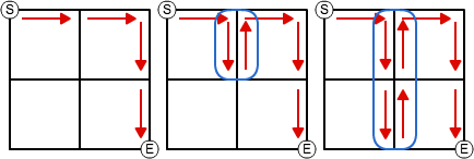
Same source/target parallel edges case
- pgRouting old issue:
ftp://ftp.remotesensing.org/pgrouting/forum/pgrouting.postlbs.org/ticket/110.html - Recent discussion:
https://github.com/pgRouting/pgrouting/issues/285
K shortest path (KSP) limitations
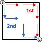
- KSP returns 1st, 2nd, ..., Kth shortest "alternative" routes
- pgr_ksp - K-Shortest Path
- KSP is not for "all possible" routes...
- KSP doesn't support "round trip" case
- To support parallel edges case, post processing becomes necessary link
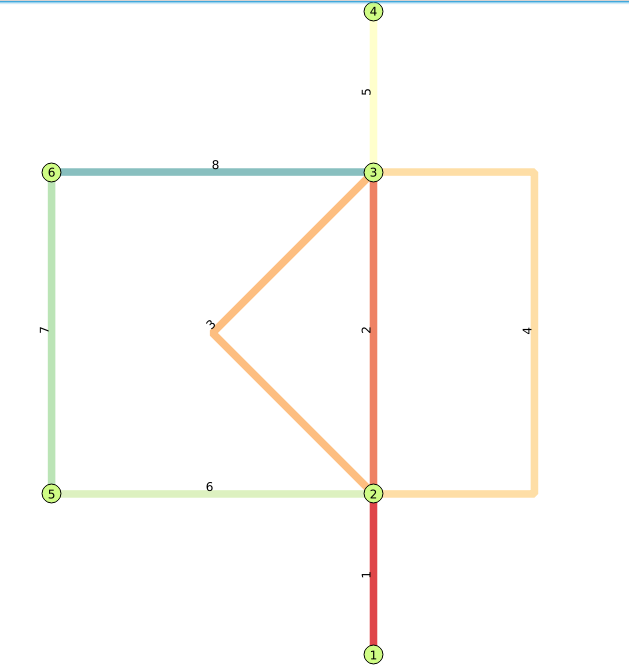
Necessity of draggable routing
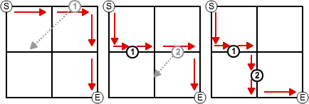
- After selecting "start"/"end" points, then drag a point on intermediate edges to on another edge
- Just do S=>1, 1=>2, 2=>E routing
- Supporting "round trip" case is possible
- To support parallel edges case, edge based routing is necessary, and "pgr_trsp" supports it
Draggable routing frameworks
- Google Maps Directions API
- Open Source Routing Machine (OSRM)
- Leaflet Routing Machine (LRM)
Google Maps Directions API
- Link: https://maps.google.com/
- Documentation:
https://developers.google.com/maps/documentation/directions/intro - Example:
Muko-shi, Kyoto, Japan (135.703151640629,34.9447239682395) - pros:
- Most well known framework
- cons:
- Closed source
- Need to get a license for commercial use
Open Source Routing Machine (OSRM)
- Link: http://map.project-osrm.org/
- Source code/Documentation:
backend: https://github.com/Project-OSRM/osrm-backend
frontend: https://github.com/Project-OSRM/osrm-frontend - Example:
Muko-shi, Kyoto, Japan (135.703151640629,34.9447239682395) - pros:
- Well known framework
- Open source
- cons:
Leaflet Routing Machine (LRM)
- Project:
http://www.liedman.net/leaflet-routing-machine/ - Source code:
https://github.com/perliedman/leaflet-routing-machine - pros:
- Open source
- License is not strict (ISC)
- Several routing engines support: OSRM (builtin default), GraphHopper, MapBox Directions API, Mapzen Valhalla, ...
- cons:
- pgRouting with own network data is not supported
Leaflet Routing Machine (LRM) pgRouting plugin
- Quick glance at LRM plugin interface
- Server side design
- Client side processing
- Demo
Quick glance at LRM plugin interface 1/2
- Tutorial / GraphHopper, Mapbox, Valhalla and other routing software / Using other routers:
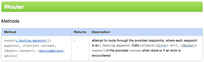
http://www.liedman.net/leaflet-routing-machine/tutorials/alternative-routers/ - Request waypoints to a server via LRM IRouter interface's "route" method
![]()
![]()
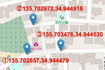
?loc=34.944479,135.702857&loc=34.944916,135.702972&loc=34.944530,135.703476
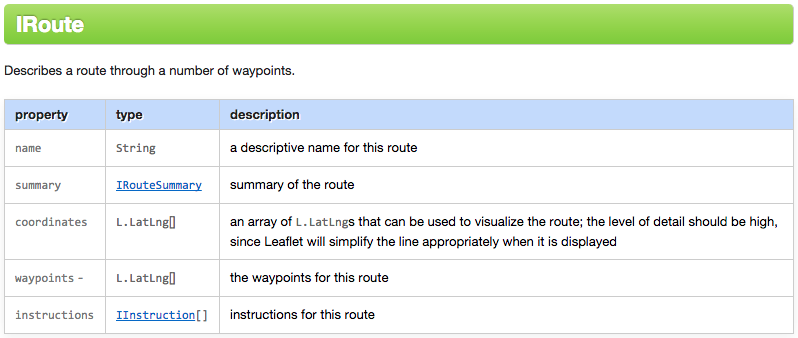
Quick glance at LRM plugin interface 2/2
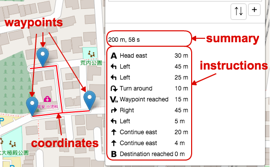
- Get response from the server
- Parse the results, then format and pass it to LRM IRoute interface object
![]()
![]()
- LRM render waypoints and coordinates in a map, and show summary and instructions in a panel
Server side design 1/3
- To make it simple, use GeoServer WFS layer (SQL View) + PL/pgSQL wrapper function
- PL/pgSQL wrapper function parses input waypoints, then call "pgr_trsp" function for each waypoints
- GeoServer doesn't support multiple geometry columns' layer, so, designed that PL/pgSQL returns merged TRSP result edges with "point type" attribute
| Value | Meaning |
|---|---|
| 1 | Edge start node is source(origin) point |
| 2 | Edge end node is target(destination) point |
| 4 | Edge start node is intermediate way point |
| 8 | Edge end node is intermediate way point |
Server side design 2/3
- PL/pgSQL wrapper function -
CREATE OR REPLACE FUNCTION routing.viaPoints(
        IN points text, -- Format: "Lng,Lat|Lng,Lat|..."
        IN tbl varchar DEFAULT 'osm_2po_4pgr'::varchar, -- Edge table name
        : -- Other default values
        OUT seq integer,
        OUT gid integer,
        OUT name text, -- Road name
        OUT heading double precision, -- Angle from edge start to edge end (not used)
        OUT cost double precision,
        OUT geom geometry, -- Edge geometry (ordered)
        OUT distance double precision,
        OUT point_type smallint -- Point type
    )
    RETURNS SETOF record AS
    :
- Parse passed waypoints text
- Find each waypoint's nearest edge, position in the edge and snapped point
- Call "pgr_trsp" function for each waypoints
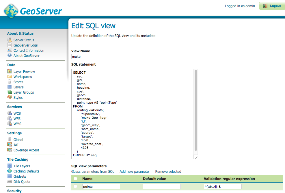
Server side design 3/3
- GeoServer SQL View settings to pass a waypoints parameter to PL/pgSQL wrapper function
Client side processing 1/5
- Request waypoints as "viewparams" value to the GeoServer WFS layer
options: {
	serviceUrl: 'http://localhost:8080/geoserver/pgrouting/wfs',
	timeout: 30 * 1000,
	urlParameters: {
		version: '1.0.0',
		request: 'GetFeature',
		outputFormat: 'application/json'
	}
},
:
route: function(waypoints, callback, context, options) {
	:
	url = this.buildRouteUrl(waypoints, options);
	:
	corslite(url, L.bind(function(err, resp) {
		:
Client side processing 2/5
buildRouteUrl: function(waypoints, options) {
	var points = [],
		i,
		baseUrl;

	for (i = 0; i < waypoints.length; i++) {
		points.push(waypoints[i].latLng.lng + '\\,' + waypoints[i].latLng.lat);
	}

	baseUrl = this.options.serviceUrl + L.Util.getParamString(L.extend({
			typeName: this._typeName,
			viewparams: 'points:' + points.join('|')
		}, this.options.urlParameters), baseUrl);

	return baseUrl;
},
Client side processing 3/5
- Get response GeoServer WFS layer
route: function(waypoints, callback, context, options) {
	:
	corslite(url, L.bind(function(err, resp) {
		:
		if (!timedOut) {
			if (!err) {
				data = JSON.parse(resp.responseText);
				this._routeDone(data, wps, callback, context);
				:
Client side processing 4/5
_routeDone: function(response, inputWaypoints, callback, context) {
	var alts = [],
	:
	for (i = 0; i < response.features.length; i++) {
		feature = response.features[i];
		edgeCoords = this._coordsToLatLngs(feature.geometry.coordinates);
		if ((feature.properties.pointType & 1) || (feature.properties.pointType & 4)) {
			viaCoords.push(edgeCoords[0]);
			viaIndices.push(routeCoords.length);
		}
		if (feature.properties.pointType & 2) {
			viaCoords.push(edgeCoords[edgeCoords.length - 1]);
			viaIndices.push(routeCoords.length + edgeCoords.length - 1);
		}
		instructions = instructions.concat(this._convertInstructions(feature.properties, routeCoords, edgeCoords));
		routeCoords = routeCoords.concat(edgeCoords);
		totalDistance += feature.properties.distance;
		totalTime += feature.properties.cost * 3600;
	}

	actualWaypoints = this._toWaypoints(inputWaypoints, viaCoords);

	alts.push({
		name: '',
		coordinates: routeCoords,
		instructions: instructions,
		summary: {
			totalDistance: totalDistance,
			totalTime: Math.round(totalTime)
		},
		inputWaypoints: inputWaypoints,
		waypoints: actualWaypoints,
		waypointIndices: viaIndices
	});

	callback.call(context, null, alts);
},
Client side processing 5/5
- Result route and waypoints are rendered in a map
- Result summary and instructions are displayed in a panel
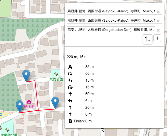
Demo
Resources
- GitHub repository:
https://github.com/sanak/lrm-pgrouting - Sample data:
- Original data: OpenStreetMap (*.osm)
- Location: Muko-shi(向日市), Kyoto(京都府), Japan
- Converted it to pgRouting edge table by osm2po
Future plans
- More simplification and test
- Try to develop OL3 custom interaction
- Try to develop QGIS Python plugin
More simplification and test
- Current implementation depends on "osm2po" converting edge table schema, so more generalization is necessary
- Currently, "instructions" contents is built at the client side, but moving its logic to server PL/pgSQL side may be better
- Currently, tested it only with small data set, so testing it with larger data set become necessary
Try to develop OL3 custom interaction
- Port LRM itself to OL3 custom interaction as "OL3 Routing Machine (ORM)"
- Port LRM pgRouting plugin to an OL3 class
Try to develop QGIS Python plugin
- Port LRM itself to QGIS Python plugin as "QGIS Routing Machine (QRM)"
- Port LRM pgRouting plugin to a Python class
- If possible, consider about direct access from "QGIS Python plugin" to "PL/pgSQL wrapper function"
Thank you!
- Email: nagase@georepublic.co.jp
- GitHub account: https://github.com/sanak